Saturday, April 17, 2010

The Utica Insane Asylum

In the heart of Utica stands an enormous Greek Revival edifice rivaling in size and grandeur the palaces of European royalty. Opened in 1843, the building is 550 feet long with a central portico of 120 feet, dominated by six limestone columns 48 feet high and eight feet in diameter.


In keeping with the values of the young American republic, this grand structure was built not for a privileged aristocracy, but for the care and treatment of the most forlorn and neglected of our citizens. When it was opened, the New York State Lunatic Asylum in Utica was the first such institution in the state and one of the first in the nation, part of a nationwide response to the call of reformer Dorothea Dix for humane treatment of the mentally ill, who were previously housed in jails or in private homes. Thomas Kirkbride, an early psychiatrist, echoed Dix’s concern by calling for huge institutions across the nation that could provide "a special apparatus for the care of lunacy, whose grounds should be highly improved and tastefully ornamented."


The first director of the Utica Asylum was Dr. Amariah Brigham, who believed that useful agricultural and other manual work could provide excellent therapy for the hundreds of patients who were soon sent to Utica from all parts of the state.  The outbuildings that once contained therapeutic workshops still stand, in good repair, on the asylum grounds, and some are in use by various state agencies. According to Marc Harf, writing in 1981 for an exhibit at the Munson Williams Proctor Institute: “The prevailing medical theory of the 1830's advocated that patients be segregated by sex and type and degree of illness, with each group housed in a self contained unit. As far as possible, the interior layout of the building was arranged to provide optimum conditions for the patients.”


Dr. Amariah Brigham

Mr. Harf  described the vast scope of the asylum: “In 1850, a listing of accommodations noted: 380 single rooms for patients, 24 for their attendants, 20 dormitories each accommodating from 5 to 12 persons, 16 parlors or day rooms, 12 dining rooms, 24 bathing rooms, 24 closets and 24 water closets. The mechanical systems of the original building incorporated the latest improvements. Hot air woodburning furnaces in the basement provided heat for the building. Ventilators opening from the rooms to flues in the walls allowed air to circulate constantly. Hot and cold running water was supplied to each floor, the cold water coming from the roof while the warm water was pumped by a steam engine from basement storage tanks.”

19th century outbuilding now housing an addiction services center


Dr. John Gray, another leading psychiatrist of the era, took over as director in 1854.   Gray’s national reputation was such that he was called in to ascertain the sanity of Charles Guiteau, the assassin of President James Garfield in 1881. (Guiteau was ruled sane and subsequently executed.) In contrast to Brigham’s belief in “moral” causes of insanity, Gray believed that mental illness was rooted in brain functions.


Dr. John Gray


Under Dr. Gray, however, the great optimism regarding such institutions began to dissipate.  Long before the insights of Freud and other pioneers, and without the medications provided by modern pharmacology, the kind of treatments pioneered by Dr. Brigham did not produce the envisioned improvements.

The definition of mental health was also, of course, conditioned by 19th century mores. Same sex orientation or any form of sexual expression, particularly by women, beyond traditional monogamy could, and did, lead to a diagnosis of insanity. Even non-traditional religious beliefs, such as those of the "Millerites," whose beliefs in an imminent Second Coming have since become a part of the American mainstream,  could be grounds for committal.

Frustrated by attempts to “cure” mental patients, other and harsher methods were tried. The “Utica Crib,” a device meant to confine patients who might harm themselves or others, may have been well-intentioned but was soon criticized widely as the equivalent to putting human beings in cages. Abuses of patients occurred, including the murder of one by an employee, and were the subject of widely publicized hearings at the state legislature. And Dr. Gray himself was shot by a former patient in 1885 and never fully recovered.


The "Utica Crib," courtesy University of Iowa Medical Museum

Other abuses were uncovered in succeeding decades and the once bright hopes of reformers grew ever dimmer, until eventually huge buildings like the Utica Asylum came to be seen as obsolete and by 1978 the Utica asylum, known locally as “The Old Main,” was closed.

In 1989 the asylum was named a National Historic Landmark and in 2005 major renovations of part of the building  took place, and now house the Records Archive and Repository for  the New York State Office of Mental Health.


Director's house on the Asylum grounds, currently vacant

The asylum grounds on Court Street today present a peaceful picture, with little to remind the visitor of the immeasurable human misery of the past. A bunch of flowers placed on the front steps, however, suggests that one anonymous visitor, at least, remembers the thousands who were incarcerated here over a period of 135 years.


 Flowers left by an anonymous visitor


Dr. John Gray appears as a character in my novel based on a notorious murder that took place only a few miles from the Utica. Asylum.  Available for $19.95 at Wilderness Hill Books. and $2.99 on Kindle.

Saturday, April 10, 2010

Dewey Loeffel and The Toxic Legacy of General Electric


 Since 1878 the General Electric Company has been a vital part of the economy and culture of this region, and is proud of its history. From its earliest days under the guiding genius of Thomas Edison, GE was a pioneer in the development of electric light, radio and television, home appliances, jet engines.  For a century and more, upstate families have grown prosperous, thanks to GE, and many local retirees still count, with some anxiety in recent years, on GE's dividends.


However, there is another legacy of GE:  the toxic byproducts of  manufacturing that were were dumped throughout the Hudson and Mohawk watershed.  Many people are familiar with GE's decades-long resistance to cleaning up the toxic sludge dumped into the Hudson from its Fort Edward plant.   Less than a month ago, the Albany Times Union reported that GE and the EPA were still clashing over the depth and frequency of the dredging that will be necessary between Fort Edward and Troy.

According to the EPA, the quantity of toxic PCBs in the river is almost triple initial estimates because "hot spots" were much deeper than predicted, and were sometimes covered with logging debris from mills upriver. EPA wants to dredge more river bottom more deeply but less often, to capture more PCBs while causing less stirring up. GE has a different view, so the cleanup slows down while the conflicting views are referred to a panel of independent experts.


The Dewey Loeffel toxic dump lies in the beautiful countryside 
north east of Nassau, NY

The Hudson River, however, is not the only place where GE dumped polychlorinated biphenyls and other industrial waste such as paints, solvents, resins and oils. Beginning in 1952, GE arranged with a Rensselaer County landowner, Dewey Loeffel, to use 11 hilly acres of his property on Mead Road in the town of Nassau as a dump site and this arrangement continued until ended by the state in 1968. (To be accurate, GE wasn't the only contributor to this dump. Bendix Corp. and Schenectady Chemicals, both still in business, gave their share.)


 The Dewey Loeffel landfill, 42 years after it was closed


Forty-two years later, poisonous chemicals  from this site are still at high levels in  the waterways of Rensselaer County, while generations of GE-hired lawyers and experts  have  dragged their heels over every attempt to clean up the 46,000 tons of carcinogenic material.

According to the EPA, GE operators had, by 1974, covered and graded the drum disposal area, oil pit, and lagoon with soil, and constructed drainage channels to control runoff. In 1980, GE entered into an agreement with NYSDEC to perform additional investigation and remediation at the facility. 

For all this time, it seems apparent that the company lacked any sense of urgency. It was not until 1980, for example, that a series of tests by the New York State Department of Environmental Conservation even determined that the toxic waste was spreading into local waterways and aquifer despite the initial work done on the dump. This discovery resulted in GE removing 500 surface drums and four 30,000 gallon oil storage tanks, and installing a NYSDEC-approved slurry wall, clay cap, and leachate collection system during the years from 1982 to 1984.


Water is still seeping from the landfill

Twenty (Yes, twenty!) years later, in 2000 GE spokesperson Joan Gerhardt said that the company would begin to remove the contaminated spill "voluntarily and at its own expense in the spring." (of 2001) Miss Gerhardt observed that this voluntary step would be "a headstart on the cleanup" while the DEC continued to mull over the company's 1998 proposal for a larger cleanup. GE, at that time, was monitoring only 22 wells in the area, even though the water from the landfill flows across two counties on its way into the Hudson at Stockport.


 A tributary of Valatie Creek a mile southwest of the Dewey Loeffel Landfill

In 2000 it was determined that the sediment in Nassau Lake, which is formed by a dam on Valatie Creek, contains 2.3 ppm of PCBs and that fish in the lake had many times that level, although the water itself had no detectable PCBs. (SOURCE)

According to the EPA, this dam keeps PCB-laden 
sediment restricted to Lake Nassau


The fish in Nassau Lake still have dangerously high  PCB
levels 42 years after Dewey Loeffel was closed

Over the next two years, the NYS Department of Environmental Conservation held many meetings with local residents and produced two lengthy  Record of Decision documents in December 2001 and January 2002.
By 2004, GE had removed approximately 15,000 tons of PCB-contaminated soil and sediments from the site drainage-way between the facility and Nassau Lake.
A person might assume in 2004 that the Dewey Loeffel mess was finally being cleaned up, 36 years after it was closed.

Not so.

The flood of paper continued over the past six years and the Town of Nassau now has on its website thirteen more documents composed from the last two years alone. The audio of the March 4, 2010 meeting is well worth listening to, because it was at this meeting that the federal EPA joined the state DEC to provide one more disappointment to long-suffering local residents.

On the audio you will hear federal EPA official Mel Hauptman tell residents that "Everyone should understand that it is a slow process" and "This area is polluted enough it could be still on the list in a hundred years when we are all gone." Using GE-provided graphics, Mr. Hauptman  took those present on a tour of the toxic sites reaching from the landfill down Valatie Creek into Nassau Lake.   Hauptman said of  fish in the lake  that "there may be a downward trend but I'm not getting too excited" since the toxicity is still so high that neither humans nor wildlife could safely eat the fish.  He tried to be reassuring to the audience  about dangers to human life and health from contaminated groundwaters and wells.

Although there was little good news for those at the meeting in the VFW Hall on Lyons Lake Road, Hauptman said that the toxic chemicals were not (yet) spreading further downstream on the Valatie Creek: "The lake is acting like a trap to keep PCBs from proceeding downstream."

However, children and pregnant women are advised to eat no fish from Kinderhook Lake, so apparently some PCBs are drifting downstream. The virtual absence of fishlife in Valatie Creek below the Niverville Dam is puzzling and may be related.


Valatie Creek flows south from Lake Nassau

through North Chatham

into Kinderhook Lake


and then joins Kinderhook Creek in the village of Valatie

Despite Hauptman's assertion that the toxic chemicals are limited to the waterways north of the Nassau Lake dam, downstream residents need to get involved in the fight that the people of Nassau have been waging for so long. Finally, under the Obama administration, there are signs of life within the previously moribund EPA and the Dewey Loeffel site is under consideration for addition to the EPA Superfund. This will, if approved,
"allow the EPA to make the responsible parties clean up their contribution to contaminating the site."

We are currently in a 60-day comment period, which began March 3,  in which the public is encouraged to voice their opinions on giving the  Dewey Loeffel  landfill Superfund status.

For instructions on submitting comments, go to:


Cross published at All Voices

Tuesday, April 6, 2010

The Tale of Harmen Meyndertz van den Bogaert - historical sources of the novel


Update November, 2017

My 2008 novel inspired by the life of Harmen van den Bogaert, The River That Flows Both Ways, has been re-issued in a new and revised edition which draws on recent research and addresses some of the inconsistencies noted by readers in the earlier edition.


Amazon Kindle at $1.99

Lulu paperback at $14.95


 The Tale of Harmen Meyndertz van den Bogaert


New Netherlands, during the six decades of its existence, was generally more tolerant than neighboring  English Puritan settlements, and had a commercial focus that has persisted through the centuries in New York.  Here in the Hudson Valley our Calvinists were of a gentler strain than in neighboring New England and we experienced no frenzied pursuit of witches or dissenters.  Despite some reluctance from Peter Stuyvesant, a band of Portuguese Jews were the first of their faith to find acceptance in the American colonies. Quakers, although not warmly welcomed, were not whipped from town to town as in Massachusetts.

 Pieter Stuyvesant, who condemned Harmen to death


And although the Dutch settlers had inherited laws from the old country making  sodomy a capital offense,  the severest  penalty appears to have been applied only twice, and then only when a child was abused.  In 1646 “Jan Creoli, a Negro, was…choked to death, and then burnt to ashes," while his ten year old victim, Manuel Congo, was merely flogged. In 1660, a soldier named Jan Quisthout was “tied in a sack and cast into the river and drowned until dead." Once again, his victim, a boy named Harmen Harmensen was whipped, but this time “privately.” (Source)


Thus, it appears that the Dutch colonists only enforced the ancient anti-sodomy code when a dependent minor was involved, (Not they showed much sympathy for the victimized youth) and that whatever same sex relationships may have existed among consenting adults was ignored by officals. A cynic might speculate that even pederasty might not have always been prosecuted, if the offender were more highly placed than either of these two men. After all, Creoli was an African and Quisthout a common soldier.

But Harmen Meyndertz van den Bogaert, a nearly forgotten figure now, was a very prosperous and influential member of the New Netherlands colony who did come into conflict with the ancient law. He was an explorer, a leading physician, a prosperous business man, and holder of high government office.  And yet he was accused of the same crime as Creoli and Qusithout, and although he cheated the executioner, he also paid with his life.

Educated in his native Netherlands, Bogaert was already a surgeon/barber when he arrived in New Amsterdam about 1630.  At some point thereafter, he moved up the Hudson to the busy trading post of Rensselaerwyck, now Albany.  This village grew up around Fort Orange and was the center of the colony’s fur trade with the powerful Iroquois Confederacy.  Equipped with muskets in exchange for furs, the Mohawks and their brother tribes ranged far north and west in pursuit of the precious beaver pelts.

 Painting of of Fort Orange by L. Tantillo (courtesy NYS Museum)


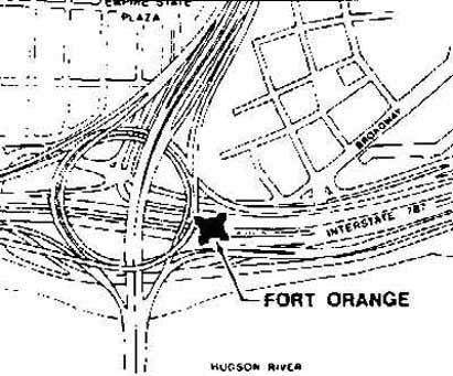
 Ruins of Fort orange were found during excavation of I-90/I-787 interchange in Albany


Then in January, 1634 the native people suddenly stopped appearing at Rensselaerwyck with their furs, and the colonists panicked. Without the fur trade, the colony would lose its entire economic foundation. French interference was suspected, and someone needed to find out what had exactly had happened to the trade.

However, the inhabitants of Rensselaerwyck did not venture into Indian country, preferring to stay put in their little version of Holland, particularly in the dead of winter. In fact, they had not ventured west of Schenectady ever since 1626 when foolish Captain Van Krieckenbeeck sided with the Mohicans and ended up getting himself and his men killed and eaten by the Mohawks. (The Mohicans usually got the worst of it in their long running wars with the Mohawks and were declining in numbers and power throughout the century)

At this point Harmen, then about 22, volunteered to lead an expedition composed of himself and two other men. He soon ventured forth into the snow-covered forests and in doing so, became the first white to reach the Mohawk Valley and to be welcomed as a guest in a series of palisaded villages stretching along the river from near present-day Amsterdam to Utica.

Harmen kept a journal, which was lost for centuries before it was found among ancient records in the Netherlands.  A new translation of the journal by Charles Gehring, director of the New Netherland Institute at the state museum, conveys a strong impression of  Harmen’s  lively curiosity and powers of observation.

George O’Connor has produced a wonderful graphic novel of the journal which I highly recommend.  (George, with the exception of myself, is the only writer to devote a book to Harmen.)

The journal offers some interesting grounds for speculation into the young explorer’s personality and interests. The glossary of the Mohawk language which he appended contains, interestingly, a number of explicitly sexual terms.  Most importantly for his community, however, was that the journey was a great success. Harmen had restored the friendship with the dangerous Mohawks and the fur trade resumed.

 
Harmen departing from Fort Orange 
( from George O'Connor's graphic novel, Journey into Mohawk Country)


 Harmen encountering a Mohawk warrior.
( from George O'Connor's graphic novel, Journey into Mohawk Country)

After this auspicious beginning as a negotiator, Harmen rose rapidly in the colony’s small hierarchy.  He invested in a piracy expedition, a popular business venture at the time, and owned a house on what is now Stone Street in Manhattan.  He married a woman named Jilisje and had four children. He treated Isaac Jogues, the French missionary who was canonized as a Catholic saint, when he arrived at Rensselaerwyck after being tortured by the Mohawks, and Jogues describes Harmen’s kindness in his letters to his Jesuit superiors. After much success as a prosperous physician and trader, Harmen was named to the post of commissary, or business agent, at the military base of Fort Orange.


Statue of Saint Isaac Jogues


This was a lucrative position and it is possible that his wealth stirred envy among the less favored and that this provoked accusations of immorality against him. Or perhaps his behavior was simply too flagrant to be ignored, even by his tolerant countrymen. Whatever the cause, Harmen was arrested in 1647 and accused of committing sodomy with his African slave Tobias. Imprisoned in Fort Orange, he and Tobias managed to escape and fled to his old friends the Mohawks. It is interesting to speculate as to why Harmen knew he could find refuge among the Mohawks. Of course, he had a history and probably many friendships among them. He knew something of their language. And they were not hostile to the Dutch, whose sole interest was in trade, not in Indian lands.

But most significantly in my view, the native people at that point did not share the homophobia of the Europeans. Their traditions, until influenced negatively by missionaries or simply by European example, fostered not just tolerance (or looking the other way, which seems to have been the practice in the Dutch colony) but allowed a special place within their culture for gay people, who were known as “Two Spirits;”  two-spirit males were extolled for their skill in women’s work and two-spirit females for their prowess in hunting and other typically masculine pursuits.

However, Harmen and Tobias did not have time to become part of this lifestyle, even if that had been their inclination. A Dutch posse set out in pursuit and found their quarry at Andagoron, a Mohawk village on the slopes of the Big Nose Mountain, a few miles west of Ossernenon, now the location of the Jesuit shrine dedicated to Isaac Jogues and his companions. A battle ensued and some Mohawk storehouses were burned before Harmen and Tobias were taken into custody. The extent of the resistance to the posse must have been considerable, suggesting that some of the Mohawks aided their old friend in the battle. (A few months later, the Mohawks, growing wise in the ways of the whites, sued the colonial government for damages, and collected.)

 Shrine of the  North American Martyrs, site of the Mohawk village of Ossernenon


 NYS Thruway and "the Noses" 
Mohawk village of Andagoron was near base of mountain on left

Taken back to Rensselaerwyck, Harmen was again imprisoned in the fort and once again he managed to escape. (That jailhouse must have been pretty flimsy. Or perhaps Harmen had sympathizers at the fort.) This time, however, he was not so lucky. While fleeing across the icy surface of the Hudson near the present I-90 bridge, he fell through the ice and was drowned.

I have been fascinated by Harmen van den Bogaert ever since discovering a brief mention of him in Russell Shorto’s Island at the Center of the World and thought for a long time about how I could tell his story as part of my fictional series on misunderstood figures from our early upstate history. The evidence as to the nature of his relationship with Tobias is contradictory. On the one hand, the young man was a slave and the power relationship suggests that he may have been coerced into sex by Harmen. This would also fit the pattern of the very limited number of prosecutions for sodomy in the colony. On the other hand, Tobias fled prison with Harmen and was with him at Andagoron when they were captured.  (His later fate is unknown.)

Van den Bogaert’s vibrant personality, as reflected in his journal and by his wide-ranging enterprises and adventures, made me want to find a way to view his life with the degree of sympathy that would be possible only in someone who did not automatically condemn his behavior. And this led me to the invention of a narrator for my novel in the person of Matouac, a young Mohican boy living in the van den Bogaert household.  I imagine this narrator as the survivor of a massacre of his clan and of captivity among the Mohawks. Alone in the world, he is not unhappy when Harmen purchases him from a Mohawk warrior and makes him, along with Tobias, an assistant in the businesses of surgery, barbering, and gun-running.

From this vantage point, Matouac is also able to observe and compare the equally incomprehensible personalities of the exuberant Harmen and the faith-driven ascetic, Isaac Jogues. The story which the young Mohican tells of the tragic fates of both these men is transcribed by another remarkable historical figure who appears in the novel: Johannes Megapolensis. This Calvinist clergyman was close to the Iroquois and later stood up against the fierce Pieter Stuyvesant on behalf of Quakers and other dissenters.

Interstate 90 bridge over the Hudson at Albany.
This is the approximate site of Harmen's final disappearance in 1647.


And so, the next time you speed across the I-90 bridge into Albany, think about Harmen van den Bogaert, who drowned in the waters below. And if you turn north onto I-787, recall the ruins of the ancient Dutch fort where he spent his last hours. Or if you continue through Albany west on the Thruway past Schenectady, try to imagine in what is now rolling farmland the walled Mohawk villages where a violent, yet loving and often tolerant, people once flourished.


Tuesday, February 23, 2010

Fort Stanwix and the Oriskany Battlefield

Last week the New York State Office of Parks, Recreation, and Historic Preservation issued a press release  detailing which state parks and historic sites would be closed in response to what Governor David Patterson has called an unprecedented budget gap. Among the sites to be closed is the Oriskany battlefield, where hundreds of New York state patriots fought and died in 1777 in order to halt a British army intent on smashing the newly declared republic.

In an era like ours when the once economically vibrant Mohawk Valley has been sadly depopulated as its industries were destroyed and sent overseas, it is time to recall the heroism of those who gave their lives in the defense of freedom.

As the fires of revolution broke out in 1775, the largely German settlers in the valley were among the strongest supporters of independence. Nicholas Herkimer, a wealthy landowner living near Little Falls, emerged as the leader of the local militia.  Even before independence was offically declared, the patriots had driven off to Canada hundreds of those who chose to side with King George III, including the powerful Johnson family whose seat was at Johnson Hall in Johnstown. (Herkimer's home and Johnson Hall are also among the sites proposed for closure.)

The revolution in the Mohawk Valley became a civil war in which the King's supporters, including five of the six Iroquois tribes, took up arms against their former neighbors and families. The British government, eager to destroy the republic, planned an invasion that would bring the Tories and their Iroquois allies back into the valley in order to wreak a bloody vengeance.

Only a single fort protected the valley from invaders who could follow water routes south from the British base at Oswego, and that was the dilapidated Fort Stanwix. This site is now part of the national park system and thus, thankfully safe from the budget axe. The Fort Stanwix National Monument  in Rome, NY  features a museum and a careful reconstruction of the fort on its original site. 


Interior of restored fort

exterior of restored fort, with dry moat

Colonel Peter Gansevoort,
American commander at Fort Stanwix

General Barry St. Leger,
commander of the British at Fort Stanwix

Barry St. Leger, a career officer in the British army, was promoted to general for purposes of the expedition he led south from Canada in July, 1777 as one prong of a triple attack designed to split and destroy the new American republic. A second prong, to be launched from occupied New York City, never took place, due to either to the British commander's lethargy or to a communications failure. The main force of 8000 troops, led south from Montreal by General James Burgoyne, was defeated at Saratoga a couple months after the events at Stanwix and Oriskany. American victory, and the independence it protected, may well have been due to the ignominious retreat of St. Leger from Fort Stanwix. But  this eventual victory was nowhere in sight as the mixed force of British soldiers, colonials who had joined the royal side, and a large force of allied Mohawk and Seneca warriors surrounded the fort.


Rome, NY today

Now at the center of the small city of Rome, the site of Fort Stanwix controlled the strategic point where the Mohawk River was only a couple miles from Wood Creek which led to Oneida Lake and other waterways  to the west.  The fort was built twenty years earlier duing the war with the French, but had fallen into disrepair by the time the Revolution broke out. Gansevoort and his force had made only partial repairs and had limited artillery when the British and their allies arrived from the west in late July.

The British had relied on small boats to carry them up the Black River from their gathering point at Oswego, down to Oneida Lake and up Wood Creek, now a small rivulet visible from bridges on West Dominick and West Liberty Streets. Gansevoort directed his men to fill in the Wood Creek channel with logs and debris, to block St. Leger's ability to bring up his artillery and heavier supplies. Despite these delaying tactics, Gansevoort's troops, along with many women and children, were soon surrounded in the fort, and fearful that they could not long withstand the siege. The murder and scalping of two girls as they gathered berries near the fort in the days before the battle,  let the besieged know that surrender was not an option.


View of Fort Stanwix restoration from
site of  the British lines in 1777
(present day East Dominick Street)


Bastion of the fort, with sentry box 

As the siege continued, Colonel Gansevoort sent out desperate appeals for help. With the new American Army under General Washington far to the south, only the local militia was able to respond. Assembling under  Nicholas Herkimer at Fort Dayton (now Herkimer, NY) this force of about a thousand men, joined by allies from the Oneida Nation, set off to rescue their countrymen. The amateur nature of this brave force was nowhere more evident than their rapid advance straight into a trap.

Oriskany Battlefield, site of the Military Road

Six miles east of the fort a thick primeval forest then covered an area of low rises and ravines along the south bank of the Mohawk River, now accessible from state route 69 between Rome and Utica. As the militia trudged along a track in the woods, called the military road, they reached a ravine. Herkimer reportedly wanted to send out flanking scouts but was stung by accusations of cowardice from his unruly troops, eager to press on to Fort Stanwix. These accusations were sharpened by the fact that Herkimer's own brother Johann had joined the Tory(or Loyalist) Americans who comprised a large part of the force besieging Stanwix.

Whatever the reason, Herkimer led his men straight into the ravine where a mixed force of Tories and their Iroquois allies lay in ambush, under the leadership of Herkimer's former neighbor, the Mohawk war chief known to the whites as Joseph Brant. In the first volley Herkimer's leg was smashed and the militia suffered fearful losses. Retreating to a low rise above the ravine, Herkimer directed his men to form a circle and fight back. After a day of continuous battle amid the ancient trees, the American lost anywhere from 500 to 700 of their original force, their enemies considerably less. The militia retreated back to present day Herkimer, NY while St. Leger continued the siege.


The ravine where the militia was ambushed

The site from which Herkimer directed the battle


Herkimer directing his troops at Oriskany
(Painting by E.N. Clark,
courtesy Utica Public Library)

Thayendenega, also known as Joseph Brant,
 commanded Iroquois and Tory  forces at Oriskany
(painting by Glibert Stuart, courtesy
 of NYS Historical Association)


As the battered militia retreated from the scene of battle on the evening of August 4, 1777, the survivor must have feared that their struggle for independence was a futile and doomed effort. The only armed force protecting the settlements of the Mohawk Valley was now shattered, and Herkimer himself died of his wounds shortly after the battle. The only regular U.S. troops anywhere near were dug in near present day Saratoga, awaiting the advance of a formidable force of regular British soldiers and hired Hessian mercenaries, and under the command of General Philip Schuyler. (whose home in Albany is also slated for closure) 

The defenders of Fort Stanwix, running low on food and ammunition, could not hold out for long and when the fort fell, St. Leger would surely unleash his allies on the unprotected settlements, stretchng east from near present day Utica to Schenectady. And the British would be free to attack the Continental army from two directions at once. The rich farmlands of the valley, which provided much of the food for Washington's army, would be in enemy hands, and defeat  of the independence movement would be only a matter of time. Britain's "counterinsurgency strategy" would have paid off.

What prevented this disaster? What saved our young republic from perishing only a year after its independence was proclaimed?

For one of several possible answers to such questions, I have to recommend my own historical novel, Neither Rebel Nor Tory, available at amazon.com.

The book is also available at the Herkimer County Historical Society, the Little Falls Historical Society, and the Blackwood & Brouwer bookshop in Kinderhook, NY.


The novel is closely based on the life of Hanyost Schuyler, Herkimer's nephew, who  was long regarded as possibly insane, a turncoat, and a shameless opportunist who fought variously for the patriot and loyalist sides. All historians agree, however, that Hanyost played a key role in persuading St. Leger and Brant to suddenly break off the siege and flee back to Canada, leaving Burgoyne to face defeat on his own.

My vision of Hanyost Schuyler, only 21 in 1777, is that his upbringing among the Mohawks near Little Falls gave him a deep affinity with native culture that made him resist taking part in the war on any side. Trapped in the middle of a battle he did not choose, Hanyost was uniquely placed to do what his uncle and no military force alone could do.

Monday, February 22, 2010

A hike to the fire tower on Beebe Hill

Beebe Hill rises 300 feet above the uplands of the Taconic range in the town of Austerlitz in Columbia County, and offers beautiful views in all directions from the firetower at the summit. The hike is an easy one, taking about an hour on a well-marked trail. Access to parking for the trail is from country road 5, which branches north from State Route 2 a few hundred feet north of the 22 and 203 intersection. Access to the trail and parking is on a dirt road at the north end of Barrett Pond.

view of Beebe Hill across Barrett Pond

Trailhead Parking

The western slopes of the Taconics were far more populated in the early 1800s than they are today, and largely settled by New England yankees who swarmed into the area just after the Revolution. Soon lured westward by new (some would say stolen) lands opened up by the defeat of the Iroquois allies of the British, many of the early farmers soon moved on. Among those who passed through was the family of Mormon prophet Joseph Smith and other Yankees who formed the core of the earliest Latter Day Saints.


The rocky farms of these early settlers have long since returned to woodland, but evidence of their presence is clear. A small cemetery adjoins the parking area, suggesting old sorrows. Ruth Browter's stone can easily be read, altho some others have become illegible. Ruth lived to age 87, dying in 1875, and rests now beside her young husband who died fifty years earlier. Many of the stones memorialize the Crowter and Harmen families and indicate an extensive settlement into the 1840s. The young are too often found here, but all were sustained by their Christian faith. On the stone marking the grave of 81 year old Deborah Goodrich can be found this poem:

Her Soul has gone to rest
While here her Body Lies
To moulder back to dust again
Till Christ shall bid it rise


Daniel Barrett is still remembered


Stone fences mark the boundaries of 19th century fields and pastures

After paying our respects to the hardy farmers who once struggled with this rocky and ungenerous soil, we set out up the trail, clearly marked with blue  markers. The climb is an easy one, suitable for children, and in winter offers numerous views of the surrounding country

Typically easy grade on this trail


Well maintained bridge on the trail

After perhaps a half hour's ascent, the trail reaches a plateau on the top of the ridge, and unless it is very dry, you will see a pond ( or tarn) to your left. Just beyond is a sturdy lean-to erected by the volunteers. Very soon you will come into a grassy area and your first view of the firetower.

Tarn on the top of the ridge

Lean-to built by volunteers

First view of the firetower

The firetower is open for hikers to climb to the top and the stairway, although steep, is enclosed for the most part. The views are beautiful in all directions: west into the higher ranges of the Taconics on the Massachusetts line and east toward the Hudson and the Catskills beyond.


Views from the firetower


The forest fire observatory on Beebe Hill operated continuously from April of 1964 until the end of the 1987 fire season. Prior to 1964 the fire tower was located on the summit of Alander Mountain from 1928 through 1930 and on Washburn Mountain from 1933 until November 1963.  Ten years after the closing of the facility, local residents came together to restore the fire tower and observer's cabin. This group also created the hiking trail system throughout the Beebe Hill State Forest.  The Beebe Hill Volunteers maintain an interesting website, which provides more of the history of the tower and information on contributing to their good work.

Hiking Mates of the Capitol Region have posted a report of a visit by 15 of their members to Beebe Hill, and provide some good photos of views from the tower.


Restored ranger cabin

An abandoned cabin
I recommend returning by the same trail and avoiding the temptation offered by a broad access road leading downhill. If you take this route, as I did,  your return walk will be closer to five miles than the one mile back to the parking area.

The road not to take back down the mountain

For those interested in another glimpse of how busy this area was back in the early 1800s, I suggest a visit to Bash Bish Falls State Park  just outside of Copake Falls, 10 miles or so south on Route 22.  In addition to the beauty of the falls itself, you can see the remains of the Copake Ironworks. In the early 1800s much of the forest in this area was cut down to provide charcoal for such early forges.


Copake Iron Works


Bash Bish Falls

And bicyclists may want to explore the three mile section of the Harlem Valley Rail Trail which follows a small piece of the old railroad route that once connected the industries of Copake with New York City and Boston, via a link at Chatham. The bike trail can be found crossing the parking lot of the Copake Falls area of the NY state Taconic Park.


Mile marker on the Harlem Valley Rail Trail
(103 miles to Grand Central Station)

The southern terminus of the Rail Trail
currently ends with this view